The Ural Federal District was formed in accordance with the Presidential Decree Russian Federation No. 849 dated May 13, 2000
The Ural Federal District includes 6 constituent entities of the Russian Federation: Kurgan, Sverdlovsk, Tyumen, Chelyabinsk regions, Khanty-Mansiysk Autonomous Okrug - Yugra and Yamalo-Nenets Autonomous Okrug.
The center of the Ural Federal District is a city (population as of January 1, 2007 - 1.3 million people).
The area of the territory of the Ural Federal District is 1788.9 thousand km2, which is 10.5% of the territory of Russia. Population of the district as of 01.01. 2007 12.2 million people, of which the urban population accounts for 79.5%, the rural population - 20.5%.
The Urals has a very favorable economic and geographical position. It is located in the central part of Russia, between developed regions and the resource-rich eastern regions of the country. The Ural Federal District is located close to both western and eastern markets for finished products.
The industrial complex of the Urals is one of the most powerful in the country. The district is distinguished by the most developed oil, gas and mining industries. The resources of manganese, iron ores, silver, copper, zinc, and gold are concentrated here. The extraction of lead, nickel, cement raw materials, and coal is of great importance. Stone mining is carried out. About 70% of Russian oil reserves and 91% of natural gas are concentrated in the district. Iron ore and non-ferrous metals occur within the Ural Mountains. More than 300 oil, gas and gas condensate fields are located on the territory of the Yamalo-Nenets Autonomous Okrug and Khanty-Mansiysk Autonomous Okrug - Ugra, including shelves. These regions belong to the West Siberian oil and gas province, which ranks second in the world in terms of geological reserves of oil and gas after the unique basin in the Persian Gulf region.
Pipeline transport plays a major role in the supply of oil and gas from Western Siberia. The oil pipelines Nizhnevartovsk - Anzhero-Sudzhensk - Irkutsk, Surgut - Polotsk, Nizhnevartovsk - Ust-Balyk - Omsk originate on the territory of the district; gas pipelines Urengoy - Pomary - Uzhgorod, Urengoy - Chelyabinsk. Oil is transported from the fields of the Yamalo-Nenets Autonomous Okrug via two main oil pipelines: Tarasovskoye - Kholmogory and Kholmogory - Western Surgut.
The region's electric power industry is represented mainly by thermal power plants. The largest of them are Surgut GRES-1 and GRES-2, Urengoyskaya and Nizhnevartovskaya GRES in the Tyumen region; Reftinskaya, Sredneuralskaya, Serovskaya, Nizhneturinskaya GRES in the Sverdlovsk region; South Ural State District Power Plant in the region.
Since 2006, the economic development of the Ural Federal District has been viewed through the prism of the “Industrial Urals - Polar Urals” project, which involves the introduction into circulation of very large resources, ensuring, first of all, stimulation of the basic sectors of the economy of the district and Russia as a whole - ferrous and non-ferrous metallurgy, metalworking and mechanical engineering. The main goal of the project is the industrial development of a new mining area in the east of the district, as well as the stable functioning of the basic sectors of the economy of the Chelyabinsk and Sverdlovsk regions. As part of the project, the development of deposits on the eastern slope of the Ural Mountains has already begun.
In Uralsk, the main infrastructure sectors of the economy - transport and communications - have become more active. Due to the higher rates of development of road and rail communications, the structure of the district’s transport complex (which is dominated by pipelines, forming about 74% of all traffic) is becoming more balanced.
Active work is carried out in the field of housing construction. Since the beginning of 2006, 1,178 thousand m2 of housing have been commissioned in the Ural Federal District, which is 22.4% more than a year ago. The leader in absolute terms is the Chelyabinsk region, where 325.7 thousand m2 of housing were commissioned during this period.
The Ural Federal District has significant forest resources. The Sverdlovsk region is home to the most important centers of the forestry, woodworking and pulp and paper industries. The production of lumber, particle boards, plywood, factory-made wooden houses, thermal insulation, finishing and other materials, wood products, and furniture has been established.
The agro-industrial complex of the Ural Federal District specializes in the production of grain (rye, spring wheat, oats) and products (meat, milk, wool).
Ural federal district
Essay
topic: “Ural Federal District”
Introduction
The Ural Federal District includes the Kurgan, Sverdlovsk, Tyumen, Chelyabinsk regions, Khanty-Mansiysk and Yamalo-Nenets Autonomous Okrugs. The center of the federal district is Yekaterinburg.
The Ural Federal District is located, on the one hand, at the junction of the most economically developed territories of Russia and Europe, on the other hand, it is their leading outpost to the most promising eastern regions in the coming decade, newly developed, rich in raw materials, fuel and labor resources - Siberia, Central Asia , China, Indochina. The Urals Federal District is located at the focus of three fuel and energy complexes of global importance: Western Siberia, including the Kara Sea shelf; Timan-Pechersk province and further the Barents Sea shelf; Caspian region and Western Kazakhstan.
The area of the federal district is 1,788.9 thousand square meters. km. or 10.5% of the territory of Russia.
The Ural Federal District occupies 10.5% of Russia's territory and accounts for 8.5% of the country's population. Moreover, 80% of the population lives in cities.
1. general characteristics Ural Federal District
The geographical position of the Urals is very advantageous: for the eastern regions it acts as a support base for their economic development, and with the western regions it is connected by the export of raw materials, but mainly by the ever-increasing mutual supply of finished industrial products. The Ural economic region is one of the main and most industrially developed regions of Russia. The basis of the industry of the Urals consists of industries developing on the basis of the use of its local natural resources: iron, copper, aluminum, nickel ores, mining chemical raw materials, forest resources.
The territory of the UER extends in the meridian direction for more than 2 thousand kilometers. Modern natural complexes of the Urals and the Urals arose in the Neogene-Quaternary times and belong to the Russian Plain, the Urals and the West Siberian Plain. The climatic characteristics of the Urals are determined by its location on the path of movement of warm, moisture-saturated air masses from the west. Therefore, the eastern regions of the Russian Plain and the western foothills of the Urals are characterized by high humidity, while in the Trans-Ural region there is relatively little precipitation.
Within the eastern part of the Russian Plain, a zonal change of landscapes is observed. There are zones of tundra, taiga, mixed forests, forest-steppe and steppe with distinct subzones. In the parts of the West Siberian Plain adjacent to the Urals, landscapes of taiga and forest-steppe with a high degree of swampiness dominate. The Urals proper is divided into the Polar Urals, Subpolar, Northern, Middle and Southern. Despite the relatively low altitudes, the Urals are characterized by a pronounced altitudinal zonation - the predominant types of landscapes include mountain steppe, mountain forest-steppe, mountain forests, mountain tundra and char.
The complex geological structure of the Urals determined the exceptional wealth and diversity of its resources, and the long-term processes of destruction of the Ural mountain system exposed these riches and made them more accessible for exploitation. The Urals are a treasure trove of metals and chemical raw materials. In terms of its wealth and diversity of natural resources, it has no equal in the world. About 1000 minerals and more than 12 thousand mineral deposits have been discovered here. The Urals ranks first in Russia in reserves of bauxite, chromite, platinum, potassium, asbestos, magnesite and magnesium salts, the reserves of which range from 65 to 100% of the country's total reserves. There are significant reserves of iron, copper and nickel-cobalt ores, oil, gas condensate, and natural gas. There are manganese ores, coal, peat, graphites, and various building materials. The Urals have significant reserves of hydrocarbon raw materials, which, due to the long-term industrial development of the Urals, have a fairly high degree of depletion1.
The territory of the district covers an area of more than 1 million 788 thousand square meters. km, which is 10.5% of the entire territory of Russia. The population of the federal district as of January 1, 2007 was 12 million 230 thousand people or 8.9% of the total permanent population of the country. More than 20 nationalities live here, about 80% of them are Russians, up to 10% are the Tatar-Bashkir population. A third of the small peoples of the North of Russia live, including 23 thousand Nenets, 20 thousand Khanty, 7 thousand Mansi and 1600 Selkup. The population density of the Ural Federal District is 7 people per square meter. km. This figure is lower only in the Siberian and Far Eastern federal districts. The central and southern parts of the federal district have the highest population density, where the density reaches 42 people/sq. km. This state of affairs is explained by the peculiarities of the geographical location of the regions and the structure of their industrial production. Moreover, 80% of the population lives in cities. The Sverdlovsk and Chelyabinsk regions are characterized by the highest degree of urbanization. The high level of education of the population and its qualifications, thanks to the concentration of large scientific centers and higher educational institutions in the Urals, provides sufficient prerequisites for economic growth based on innovation.
The largest cities of the Ural Federal District are Yekaterinburg, Chelyabinsk, Tyumen, Magnitogorsk, Nizhny Tagil, Kurgan, Surgut, Nizhnevartovsk, Zlatoust, Kamensk-Uralsky. The population of other cities does not exceed 190,000 people. Yekaterinburg and Chelyabinsk are millionaire cities. In total, there are 112 cities in the district.
The population density of the Ural Federal District is 7 people per square meter. km. This figure is lower only in the Siberian and Far Eastern Federal Districts.
Table 1. Some indicators of socio-economic development of the Ural Federal District in 2008
| Index | Level |
| Industrial production index | 109,5% |
| Products (works, services) produced | 1400 billion rubles. |
| Share of the Ural Federal District in the production of industrial products in the Russian Federation | 19,5% |
| Industrial Producer Price Index | 106,5% |
| Share of the Ural Federal District in total agricultural production | 6,6% |
| Wholesale trade turnover of wholesale trade organizations | 526 billion rubles. |
| Retail turnover | 380 billion rubles. |
| Consumer price index | 110,3 |
| Foreign trade turnover* | $23.8 billion |
| Share of foreign trade turnover of the Ural Federal District in the total foreign trade turnover of the Russian Federation | 18,8% |
| Investments in fixed assets in the Ural Federal District | 449 billion rubles |
| Share of investments in fixed capital in the Ural Federal District in the total volume in the Russian Federation | 20,5% |
| Producer price index in construction | 112,1% |
| Produced paid services to the population | 115 billion rubles. |
| The volume of foreign investment in the non-financial sector of the district's economy | $5.6 billion |
| Receipt of tax payments |
551 billion rubles |
The degree of concentration of industrial production in the Urals is four times higher than the national average. Industry is represented by the fuel industry, mechanical engineering, ferrous and non-ferrous metallurgy. These industries are the basis of the district’s economy, which remains focused on raw materials. The natural resources of the Ural Federal District are 70% of Russian oil reserves, 91% of natural gas reserves, 15.5% of iron ore, 38.4% of steel, 37% of rolled ferrous metals. The fuel industry plays a leading role in the economy.
In terms of geological oil reserves, the West Siberian oil and gas province ranks second in the world after the unique basin in the Persian Gulf region. Despite the fact that a powerful oil refining industry has been created in the Ural Federal District, many large oil fields have already been largely depleted.
Table 2. Reserves of main minerals in the territory of the Ural Federal District, as a percentage of those available in Russia.
Most of Russia's oil and gas resources are concentrated in the Ural Federal District. Accordingly, gas production (92% of the all-Russian total) and oil (65%) play a leading role in the district’s economy. The main oil and gas fields are concentrated in the Yamalo-Nenets and Khanty-Mansi Autonomous Okrugs. There are also oil and gas fields in the Tyumen region.
The production of manganese ores, accounting for 9% of the all-Russian total, is concentrated in the Chelyabinsk region. The district is rich in iron ore deposits, distributed over three regions: Tyumen, Sverdlovsk and Chelyabinsk. The volume of iron ore production in the Ural Federal District is 21% of the all-Russian total.
Among non-ferrous metals, it is worth noting the large reserves and production of copper (8% and 11% of the all-Russian level, respectively) in the Sverdlovsk region. And also large developments of zinc deposits, the extraction of which accounts for 33% of the Russian volume, despite the fact that only 7% of Russian reserves are located in the Ural Federal District.
Among precious metals, the district has reserves of gold and silver (8% and 6% of the all-Russian reserves, respectively). At the same time, 21% of Russian silver is mined in the Ural Federal District. Also in the Ural Federal District there are significant reserves of lead, nickel, cement raw materials, and coal. Deposits of chrome ores, titanium and phosphorites have been explored.
The basis of the economy of the Ural Federal District is the fuel and energy complex, based on the richest oil and gas reserves in Russia. Ferrous and non-ferrous metallurgy, concentrated in the Sverdlovsk and Chelyabinsk regions, plays an important role in the economy of the district.
Mechanical engineering and metalworking are developed in the district. At the same time, the Chelyabinsk region specializes in the production of tractors, cars, road construction and mining equipment, instrument making and machine tool manufacturing; Sverdlovsk region for the production of energy, transport and chemical equipment; Kurgan region in agricultural, chemical, printing engineering. There are a large number of military-industrial complex enterprises in the district.
The electric power industry plays a significant role in the economy of the Ural Federal District, and the nuclear industry is developed. The food industry and the building materials industry are relatively developed.
In 2008, the Ural Federal District ranked 3rd in terms of industrial output among the Federal Districts. At the same time, in terms of the volume of investments in fixed capital and construction, the Ural Federal District is second only to the Central Federal District.
Table 3. Volume of industrial production of the Ural Federal District in 2008
| Million |
rubles |
rubles |
|
| industrial products of the Ural Federal District, %) | 8 498 | 100 | |
| Russian Federation, billion rubles | 1 369 256 | 19,5 | 100 |
| Ural federal district | 20 858 | 0,3 | 1,5 |
| Kurgan region | 302 978 | 4,3 | 22,1 |
| Sverdlovsk region | 786 205 | 11,2 | 57,4 |
|
Tyumen region including: |
575 777 | 8,2 | 42,1 |
| Khanty-Mansiysk Autonomous Region district | 179 907 | 2,6 | 13,1 |
| Yamalo-Nenets Aut. district | 259 215 | 3,7 | 18,9 |
Chelyabinsk region
The Ural Federal District is a leader in Russia in finished steel products, production of steel and steel pipes, that is, in ferrous metallurgy products. Among the specialized industries in the district, heavy mechanical engineering, represented by the production of bulldozers, combines, mini tractors, and instrument making, represented by the production of milking machines and electric meat grinders, should be highlighted.
Significant forest resources of the region form the timber industry complex of the Ural Federal District. The most important centers of the forestry, woodworking (Serov, Severouralsk, Verkhoturye) and pulp and paper industries (Novaya Lyalya) are located in the Sverdlovsk region. The production of lumber, particle boards, plywood, factory-made wooden houses, thermal insulation, finishing and other materials, wood products, and furniture has been established. Timber processing is carried out in the cities of Tyumen, Salekhard, Tobolsk, Surgut, Nizhnevartovsk.
Fur-bearing animals (mink, arctic fox, fox, sable, muskrat, hare), ungulates (elk, wild boar), brown bear, waterfowl (ducks, geese), and upland game (partridges, wood grouse, black grouse, hazel grouse).
The specialization of the agro-industrial complex of the Ural Federal District is grain (spring wheat, rye, oats) and livestock products (milk, meat, wool). In the northern regions of the Tyumen region, reindeer husbandry and fur farming are developed, and in the southeastern part of the Kurgan region - sheep breeding. The food industry is represented by flour mills, dairies, and meat processing plants.
Transport plays a huge role in the functioning of the economic complex of the Ural Federal District. The region is dominated by railway transport, which has both intra-regional and transit significance. The Trans-Siberian Railway passes through the territory of the district. Such well-known oil pipelines as Nizhnevartovsk - Anzhero-Sudzhensk - Irkutsk, Surgut - Polotsk, Nizhnevartovsk - Ust-Balyk - Omsk, gas pipelines Urengoy - Pomary - Uzhgorod, Urengoy - Chelyabinsk originate in the district. In the structure of exports from the Urals, the main positions are occupied by oil and gas, followed by products of metallurgy, mechanical engineering, and the chemical and forestry complex; The import structure includes light goods, food industry, medicines, machinery and equipment, ores and concentrates. In terms of export volume, the Urals Federal District exceeds all other districts.
2. Main industrial centers and nodes
The Kurgan region is located in the southwest of the West Siberian Plain, in the basin of the middle reaches of the Tobol River. The distance from Kurgan to Moscow is 1973 km. The area of the region is 71 thousand km2 (0.4% of the territory of the Russian Federation). Main cities: Kurgan, Shadrinsk.
The Trans-Siberian Railway passes through the Kurgan region. All major cities are located on it, but the overwhelming volume of intra-regional transport is accounted for by road transport.
The population of the region as of January 1, 2006 was 1096.2 thousand people, which is equal to 0.75% of the total population in the Russian Federation. The share of the urban population is 55.3%, rural – 44.7%. The region is home to 0.73% of the country's total working population. Since 1991, as a result of unfavorable demographic processes, the region's population has decreased by 13 thousand people. Average life expectancy during this period decreased by 1.93 years.
In terms of the overall level of economic development (in accordance with its integral comprehensive assessment), the region ranks 72nd among the constituent entities of the Russian Federation. Its share in the production of the country's gross domestic product is 0.39%. The average per capita volume of the gross regional product is about 52% of the average level in Russia, and when calculated taking into account the purchasing power parity of the population - 63%.2
The average per capita cash income of the population in the region is 1.8 times less than the similar Russian average. At the same time, the cost of the standard consumer basket at the end of 1999 was 14% below the national average, which could not compensate for the lag in income. In general, since 1991, the level of real cash income of the population in the region has decreased by 3.5 times. The current financial situation of the region is much less stable than in the Russian Federation as a whole. The share of unprofitable enterprises in all sectors of the economy in 1999 was about 60%. From the territory of the region, the country's budget system received taxes and fees amounting to 2313.4 million rubles, or 0.3% of their all-Russian volume (calculated per capita - 35% of the level of the Russian Federation), including the federal budget - 707.5 million rubles. (0.2%).
The Kurgan region does not have its own fuel industry; the balance of electricity production and consumption has a negative balance. All consumed fuel resources are imported to the Kurgan region from other regions of the Russian Federation: 0.8 billion m3 of gas from Western Siberia; 791 thousand tons of Kuznetsk and Ural coals; 566 thousand tons of petroleum products, including 168 thousand tons of heating oil, 162 thousand tons of gasoline and 236 thousand tons of diesel fuel.3
The Sverdlovsk region is located mainly on the eastern slopes of the Middle and Northern Urals, as well as in the adjacent territories of the West Siberian Lowland. The area of the region is 194.8 thousand km2 (1.2% of the territory of the Russian Federation).
There are a total of 47 cities in the region. The largest of them are: the regional center of Yekaterinburg, Nizhny Tagil, Kamensk-Uralsky, Pervouralsk, Serov, Asbest. The Middle Urals are strongly flattened, the western foothills are more elevated (average height - 300–500 m). The highest peak in the region is Mount Kozhakovsky Kamen (1569 m).
The region has a developed railway network connecting it with the western and eastern regions of Russia and the CIS countries. The operational length of public railway tracks is 3.6 thousand km.
The population of the region as of January 1, 2006 was 4602.6 thousand people, which is equal to 3.16% of the total population in the Russian Federation. The share of the urban population is 87.4%, rural – 12.6%. The region is home to 3.20% of the country's total working population. Compared to 1991, as a result of unfavorable demographic processes, the region's population decreased by 182 thousand people. Average life expectancy during this period decreased by 2.38 years.
In terms of the overall level of economic development (in accordance with its integral comprehensive assessment), the region ranks 13th among the constituent entities of the Russian Federation. Its share in the production of the country's gross domestic product is 3.19%. The average per capita volume of the gross regional product is about 100% of the average level in Russia, and when calculated taking into account the purchasing power parity of the population - 109%.
The average per capita cash income of the population in the region is 15% lower than the similar Russian average. At the same time, the cost of the standard consumer basket at the end of 1999 was only 1% below the national average. In general, since 1991, the level of real cash income of the population has decreased by 30%.
The Tyumen region is a subject of the Russian Federation and is part of the Ural Federal District.
The administrative center is Tyumen.
It borders with the Omsk, Kurgan, Sverdlovsk, Tomsk regions, the Nenets Autonomous Okrug, the Komi Republic, the Krasnoyarsk Territory, as well as the North Kazakhstan region of Kazakhstan; the only region of Russia stretching (together with autonomous okrugs) from the Arctic Ocean in the north to the state border in the south.
In terms of population, the region ranks 11th in Russia (3323.3 thousand people in 2006, 3430.2 thousand in 2010) and is the leader among the regions of Western Siberia. In terms of population density (2.4 people/km²) - 75th place in Russia and 3rd among the regions of Western Siberia, and in terms of urbanization level (78.6%; in 2010 - 79.8%) - 18th place in Russia and 4th among the regions of Western Siberia (2005).
The Tyumen region contains the bulk of the country's oil and gas reserves. The total volume of exploration drilling exceeded 45 million m. Oil production is concentrated in the middle Ob region. Gas is produced mainly in the northern regions. Large oil fields - Samotlorskoye, Kholmogorskoye, Krasnoleninskoye, Fedorovskoye, gas fields - Urengoyskoye, Medvezhye, Yamburgskoye. Depth of occurrence is from 700 m to 4 km. Peat, sapropels, quartz sands, and limestones are extracted. About 400 deposits of raw materials for the production of building materials have been explored. Ore minerals and precious stones have been discovered on the eastern slope of the Subpolar and Polar Urals.
The region is rich in fresh water reserves, which are represented by large rivers - Ob, Irtysh, Tobol, lakes (650 thousand) - Chernoye (224 km²), Bolshoy Uvat (179 km²), etc., groundwater, which contains more than half of Russian reserves iodine (30 mg/l) and bromine (40–50 mg/l).
In terms of forest resources, the region ranks third in the Russian Federation after the Krasnoyarsk Territory and the Irkutsk Region. The total timber reserve is estimated at 5.4 billion m3.
In terms of volume of industrial output, the region ranks 1st in Russia. The main branch of specialization is the fuel industry, which accounts for 86.4% of the region's industrial production. A significant part of the country's oil (64%) and gas (91%) is produced in the Tyumen region. In 2003, 283 million tons of oil and gas condensate and 564 billion cubic meters of natural gas were produced.
Processing of hydrocarbon raw materials is carried out by plants in the cities of Gubkinsky, Muravlenko, Surgut; Belozersky and Yuzhno-Balyksky gas processing plants. The country's largest oil refinery is located in Tobolsk. It includes several powerful oil and gas processing facilities.
The specialization coefficient (per capita production) for oil is 30, for gas – 41.
The electric power industry has received significant development - 7.2%, Surgut (GRES-1 and GRES-2), as well as Nizhnevartovskaya GRES are the largest electricity producers in Russia, operating on associated gas and providing electricity to the oil and gas complex of the Khanty-Mansi Autonomous Okrug.
The main focus of mechanical engineering enterprises (3.6%): oil field, geological exploration, oil refining equipment, tractor trailers, woodworking machines. Main enterprises: Tyumen Battery Plant, Tyumen Engine Builders, OJSC Neftemash.
The chemical and petrochemical industries produce butadiene, synthetic resins, and polyethylene pipes. About a third of the volume of liquefied domestic gas is produced.
The forest chemical complex is represented mainly by the logging and wood processing industries. A significant part of the wood is still removed from the subdistrict in unprocessed form (roundwood, ore stand, firewood). Thus, the oil and gas reserves available in the Tyumen region have created the prerequisites for the development of not only a powerful oil and gas industry, but also determine the development of other industries.
The region is characterized by harsh natural and climatic conditions; 90% of the territory is classified as the Far North or equivalent to it. Only 3% of the region's territory is occupied by agricultural land. More favorable climatic conditions in the south make it possible to grow grain, potatoes, vegetables, roughage and succulent feed; the presence of large areas of hayfields and pastures creates favorable conditions for dairy and meat animal husbandry. About 80% of the region's agricultural products are produced here. Agricultural organizations of the autonomous okrugs specialize in the production of milk, eggs, and vegetables in protected soil. Traditional trades for the indigenous peoples of the North have been developed - reindeer herding and fishing.
The Chelyabinsk region is located on the eastern slopes of the Southern Urals and adjacent territories of the Trans-Ural Lowland. The distance from Chelyabinsk to Moscow is 1919 km. The territory of the region is 87.9 thousand km2 (0.5% of the territory of the Russian Federation). Main cities: Chelyabinsk, Magnitogorsk, Zlatoust, Miass, Kopeisk, Korkino, Troitsk.
The operational length of public railway tracks is 1.8 thousand km, the length of paved roads (including departmental ones) is 15.9 thousand km (72% of the total length). Transit oil and gas pipelines have been laid across the region, and air transport has been developed.
The population of the region as of January 1, 2006 was 3666.8 thousand people, which is equal to 2.52% of the total population in the Russian Federation. The share of the urban population is 81.3%, rural – 18.7%. The region is home to 2.51% of the country's total working population. Compared to 1991, as a result of unfavorable demographic processes, the region's population decreased by 48 thousand people. Average life expectancy during this period decreased by 2.22 years.
In terms of the overall level of economic development (in accordance with its integral comprehensive assessment), the region ranks 15th among the constituent entities of the Russian Federation. Its share in the production of the country's gross domestic product is 2.22%. The average per capita volume of the gross regional product is about 89% of the average level for Russia, and when calculated taking into account the purchasing power parity of the population - 98%.4
The Chelyabinsk region has its own developed electric power industry, represented by a centralized system of energy facilities (CHP, CPP, power lines, etc.). The total installed capacity of power plants in the region is 4,798 MW, including Troitskaya GRES - 2,059 MW (43%). The main fuel at power plants in the region is coal, including high-ash Ekibastuz coal (Table 28).
Electricity production at power plants in the region in 1991–1999 decreased by 1.6 times (from 29.25 billion to 17.8 billion kWh) and does not fully satisfy internal needs (29.83 billion kWh). The electricity deficit (12.03 billion kWh) is covered by transmission from the UES of the Urals.
In 2005, the industrial production index for the main types of production activities for the full range of manufacturing organizations in the Chelyabinsk region amounted to 104% compared to the corresponding period last year.
This is ensured primarily due to growth in manufacturing – 105.4%. The volume of mineral extraction is at the level of last year – 100.3%.
At the same time, a decrease was noted in the production and distribution of electricity, gas and water - 95.8% by 2004.
Agricultural output in 2005 amounted to 35.9 billion rubles, or 126.5% of the 2004 level.
The results of the 2005 harvest have been summed up. In farms of all categories, the gross harvest of grain crops amounted to 1473.6 thousand tons in weight after processing (181.6% compared to the same period last year), potatoes - 969.1 thousand tons (186.3%), vegetables - 276, 9 thousand tons (119.3%).
The procurement of feed for public livestock farming has been increased - 26.1 centners of feed units per conventional head of cattle compared to 16.1 centners in 2004.
In 2005, the volume of investment in fixed capital for the full range of enterprises was estimated to be 72.6 billion rubles, or 108.6% of the 2004 level.
The growth in investment volumes is explained by the implementation of modernization programs at a number of large enterprises in the region, due to which new technological lines, modern units, workshops, and other capacities are being commissioned.
To replace the old two-bath steel-smelting units in the open-hearth shop of Magnitogorsk Iron and Steel Works OJSC, an electric steel-smelting shop with two electric furnaces will soon be built. With the launch of the electric furnace melting shop, the annual volume of steel at OJSC MMK will increase by 2.5 million tons.
In 2005, the revenue side of the consolidated budget of the region (according to the Ministry of Finance of the Chelyabinsk Region) received 41.6 billion rubles of tax and non-tax payments, which amounted to 104.7% of the annual planned assignments for 2005 and 109.4% by 2004 in comparable conditions.
Tax and non-tax revenues of the regional budget amounted to 30.9 billion rubles (102.9% of annual planned assignments) and exceeded last year's revenues in comparable conditions by 7.1%.
A decrease in own budget revenues occurred in 6 municipalities: Argayash (by 36.6% compared to 2004 in comparable conditions), Nagaibak (by 28.3%), Kunashak (by 13.3%), Chebarkul (by 7.4%). ), Bredinsky (by 0.6%) and Yemanzhelinsky (by 0.4%) municipal districts.
According to the territorial body of the Federal State Statistics Service for the Chelyabinsk region for 2005, 1090 large and medium-sized enterprises (63.3% of the total number of organizations) received a profit in the amount of 62,942.2 million rubles (8.2% less than in 2004). The amount of losses of unprofitable enterprises amounted to 4808.9 million rubles (113.2%).
The highest growth rates of the balanced results of enterprises' activities (profit minus loss) were noted for the following types of economic activity: “Hotels and restaurants” (3.7 times compared to 2004) and “Transport and communications” (2.1 times).
A high level of monetary income of the population is the basis for economic growth due to increased domestic demand, promotes investment activity and the attractiveness of the region, and ensures a decent level and quality of life for the population.
There were positive changes in the standard of living of the population in 2005: the monetary income of the population increased by 33.7% and amounted to 275.4 billion rubles.
Retail trade turnover in 2005 amounted to 147 billion rubles, which is 27.7% higher than the 2004 level. In the region, goods worth about 400 million rubles were sold daily, compared to 280 million rubles in 2004. This indicates that last year the main trends in the development of the consumer market were stability, dynamism and a high degree of product saturation.
In the commodity structure of retail trade turnover, the share of food products was 48%, non-food products – 52%.
In 2005, there was an increase in the share of the organized trade sector and a decrease in trade in markets. The share of sales of goods by trading organizations and individual entrepreneurs operating in a stationary trading network was 80.9%, the share of sales in markets was 19.1% (in 2004 - 77.1% and 22.9%, respectively).
During January-December 2005, 670.2 thousand people applied to the state employment service (CES) of cities and districts of the region. The number of unemployed citizens registered with the Labor Center in search of work as of January 1, 2006 amounted to 40.5 thousand people, which is 19.8% less than in 2004.
The number of citizens recognized as unemployed, compared to the same period last year, decreased by 1.0 thousand people or 1.3% and amounted to 77.8 thousand people.
As of January 1, 2006, the number of unemployed citizens was 36.3 thousand people, the level of registered unemployment in the region was 2.1% of the economically active population. Since the beginning of the year, the number of unemployed people registered with the Employment Center has decreased by 8.0 thousand people.
The share of exports in foreign trade turnover was 75.8%, imports – 24.2%. The trade balance was positive - 3240.4 million US dollars.5
Khanty-Mansiysk Autonomous Okrug - Ugra - a subject of the Russian Federation (as part of the Tyumen region). It is part of the Ural Federal District.
The administrative center is Khanty-Mansiysk.
Borders: with the Yamalo-Nenets Autonomous Okrug, Krasnoyarsk Territory, the south of the Tyumen region, Tomsk, Sverdlovsk regions and the Komi Republic.
The population of the district is 1520 thousand people. (2009) (in 2008–1505.2 thousand), population density – 2.8 people/km² (2009), share of the urban population – 91.5% (2009). The average monthly income per capita in March 2009 was 27,968.3 rubles, and the average salary in the district was 40,362.5 rubles.
The Yamalo-Nenets Autonomous Okrug is a subject of the Russian Federation (as part of the Tyumen region), part of the Ural Federal District.
The administrative center of the district is the city of Salekhard.
It borders with the Nenets Autonomous Okrug, the Komi Republic, the Khanty-Mansiysk Autonomous Okrug, and the Krasnoyarsk Territory.
The region occupies one of the leading places in Russia in terms of hydrocarbon reserves, especially natural gas and oil.
Population – 543,651 people. (2009). Population density – 0.7 people/km² (2009), share of the urban population – 84.9% (2009).
Conclusion
The Ural Federal District includes the Yamalo-Nenets Autonomous District, the Khanty-Mansi Autonomous District, the Sverdlovsk, Kurgan, Tyumen and Chelyabinsk regions.
The Urals are the oldest mining center in Russia, where a wide variety of mineral resources have long been mined and a diversified manufacturing industry is developing. Disturbance of natural complexes and increased pollution of air, water and soil are observed in the Ekaterinburg-Nizhny Tagil area with an area of several tens of thousands of km.
The geopolitical position of the Ural Federal District is determined by its economic and geographical position in the depths of the Eurasian continent at the junction of the European and Asian subcontinents. The transit location of the Ural Federal District at the junction of economic interests and the resulting large flows of goods, raw materials and people has led to the powerful development of the main transport infrastructure in the east-west and north-south directions.
One of the most important problems of the Urals is the technical re-equipment and reconstruction of industrial enterprises, primarily metallurgical and machine-building. Without this, in the conditions of transition to a market economy, it is impossible to ensure the competitiveness of products produced by its enterprises. Of particular importance for the region, given its specifics, is the implementation of programs for the conversion of the military-industrial complex.
General characteristics of the West Siberian economic region of Russia, assessment of its natural resource potential. Population composition and labor resources. Description of the leading industries: fuel and energy complex, ferrous and non-ferrous metallurgy.
Regional economics: concept, subject and objectives. Characteristics of natural resources and energy potential of the Volga Federal District. Resource assessment and socio-economic situation of the Orenburg region and the Republic of Bashkortostan.
Ostov region is a subject of the Russian Federation. The sovereignty of the Federation extends over the entire territory of the region. The region is part of the Southern Federal District (SFD), and the city of Rostov-on-Don is the capital of the district.
The current state of the economy of the city of Nizhnevartovsk, local specifics, the proportion of industrial production, the composition of the population, the role of the climatic factor. Development of other industries. Territorial and sectoral characteristics of the city.
Study of foreign economic activity of the Russian Federation in the context of the development of the world economy. Study of the dynamics of exports (fuel and energy products, timber, pulp and paper products) and imports (industrial machinery and equipment) of Russia.
Industry of the pre-revolutionary Urals. Modern geography of economic sectors. Intra-district location of the machine-building and metalworking industries. Territorial organization and prospects for the development of the economy of the Urals.
Administrative-territorial composition: Kurgan, Sverdlovsk, Tyumen, Chelyabinsk regions. Yamalo-Nenets and Khanty-Mansiysk-Ugra autonomous okrugs.
Territory- 1767.1 thousand km 2.
Population- approximately 12.6 million people.
Administrative center- Yekaterinburg city.
The Ural Federal District is located on territory belonging to two economic regions. The district unites the eastern part of the Ural economic region and the Tyumen region, which belongs to the West Siberian economic region.
The Ural Federal District has developed oil and gas industry, scooping and non-ferrous metallurgy, mechanical engineering, chemical, forestry and woodworking industries.
The district's specialization sectors can be considered the fuel industry, including oil and gas production, and ferrous metallurgy. The development of the fuel industry is associated with the location of the West Siberian oil and gas province on the territory of the district.
Indicators of the Ural Federal District
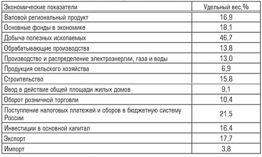
The district specializes in the extraction of fuel and energy minerals, metallurgical production and the production of finished metal products.
The high share of extraction of fuel and energy minerals (47.3%) in the structure of industrial production reduces localization coefficients for other types of economic activity. The development of the fuel industry is associated with the location of the West Siberian oil and gas province on the territory of the district.
In the Khanty-Mansiysk and Yamalo-Nenets Autonomous Okrug, oil and gas fields related to the West Siberian oil and gas province are explored and exploited, which contains 66.7% of oil reserves (6% of the world's) and 77.8% of gas (26% world reserves).
Let us characterize the distribution of productive forces across the territories of the district: the eastern part of the Ural economic region and the Tyumen region.
Economy and economy of the Ural Federal District
The Ural Federal District is located on the border of Europe and Asia and occupies 10% of the territory of Russia. The district concentrates about 9% of Russia's population. Center - Yekaterinburg. The Urals are called gray. This is not just a poetic image - the Urals are really old. The centuries-old restructuring of the mountains, the presence of its foothills either at the bottom or on the coast of ancient seas, volcanic eruptions, earthquakes and other cataclysms ultimately brought benefit to people by making the subsoil accessible. The Ural Mountains contain almost the entire Mendeleev system of elements: gold, platinum, silver, asbestos, sulfur, bauxite, iron ore, copper, nickel, chromium, titanium, vanadium, potassium and table salt, gems (malachite, jasper, amethyst), etc.
Eastern foothills (Trans-Urals), composed of igneous rocks, they are especially rich in ore minerals, primarily copper. The main copper mining in Russia takes place at the Gaisky (near Orsk), Sibaysk (near Magnitogorsk), Revdinsk, and Krasnoturinskoe deposits. Copper production plants operate in Mednogorsk, Revda, Krasnouralsk, and Kirovograd.
Aluminum smelters using local bauxite are located in Krasnoturinsk and Kamensk-Uralsk. Nickel plants in Orsk and Verkhny Ufaley also use local raw materials. There are several nickel ore deposits in the region.
Lipovskoe (Rezhevskoe) is one of the largest. It is currently being intensively developed.
The Urals have long been famous for their centuries-old traditions metal smelting, with roots going back to the first Demidov factories. Currently, Magnitogorsk, Nizhny Tagil, and Chelyabinsk metallurgical plants are operating.
Chelyabinsk Metallurgical Plant "Mechel" is one of the largest ferrous metallurgy enterprises in Russia. The enterprise consists of about one hundred divisions, united into large productions: coke-chemical, sinter-blast furnace, steel-smelting, rolling, special electrometallurgy. The plant's products are supplied both to Russian enterprises and to foreign countries. This is commercial cast iron, rolled carbon, structural, tool, bearing, electrical, corrosion-resistant steels and alloys.
The Chelyabinsk Electrometallurgical Plant produces ferroalloys: ferrochrome, ferrosilicon, ferrosilicochrome. Half of the plant's products are exported to more than 50 countries, including the USA, Germany, Japan, Great Britain, and Sweden.
The Chelyabinsk Electrolytic Zinc Plant is the largest zinc producer in Russia. The quality and stability of the chemical composition of non-ferrous metals produced by the plant are quite high: zinc content is 99.975%, cadmium - 99.98, indium - 99.999%.
Ferrous and non-ferrous metallurgy enterprises of the district are the base for factories metal-intensive mechanical engineering and chemical enterprises.
The Chelyabinsk Pipe Rolling Plant produces pipes of various diameters, including for oil and gas pipelines with a diameter of 1220 mm. The Anker metal structures plant produces equipment for coke, metallurgical, oil refining and chemical industries. It should be noted that in recent years, the Anker plant has been actively developing new projects and technologies that meet international standards. Some projects of recent years: foundry yard of a slag granulation plant (for India), a plant for the production of fuel from coal dust (for France), anchor columns of a metallurgical plant (for Finland).
The region's mechanical engineering represents tractor plant(Chelyabinsk), which is the leading enterprise of the domestic tractor industry. In addition to powerful crawler tractors, bulldozers and engineering vehicles (trench excavators, pipe layers), the plant produces mini-tractors, which are in great demand among Russian farmers.
Energy, mining and steel rolling equipment is produced in Yekaterinburg; in Kurgan - buses; in Nizhny Tagil - freight cars; in Miass - Ural trucks.
Chemical industry in the district is represented by the Oxid enterprise (Chelyabinsk), which ranks second in Russia in the production of dry zinc white (the raw materials are the products of the electrolytic zinc plant). The company also produces a wide range of anti-corrosion coatings and other chemical products for the tire, rubber, paint and varnish and pharmaceutical industries.
Currently 90% Russian gas It is mined in the north, in the Yamalo-Nenets Autonomous Okrug: Urengoy, Yamburg, Medvezhye. 70% of Russian oil comes from the fields of the Middle Ob region. The largest of them is Samoglorskoye, as well as Ust-Balyk spit, Megionskoye, Fedorovskoye.
Square(thousand km 2) 1788.9 (10.5% of the territory of Russia);
Population(million people) 12.4 (8.5% of the country’s population);
Population density(persons per 1 km 2) 7;
Number of cities 112;
District center city of Yekaterinburg;
Big cities Zlatoust, Kamensk-Uralsky, Kurgan, Magnitogorsk, Nizhny Tagil, Chelyabinsk.
A harsh picture of the tundra kingdom, surprising in the summer with the splendor and diversity of its herbs and an abundance of berries, forest-tundra with lonely trees, fragrant taiga wilds and colorful mixed forests, birch forest-steppes, flowery meadows of cereals and variegated grasses all this is the Ural Federal District. The territory of the district is occupied by the West Siberian Plain, and in the west are the eastern slopes of the Ural Mountains.
This wonderful region in many respects, with countless valuable natural resources and a colorful history, attracts tourists. Grandiose Ural Mountains with bizarre rocks, sharp ridges and descending stone rivers, they call travelers from all over the world their attractions. You will see amazing festive mountain landscapes Ilmen, amazing with their freedom and wealth of animals and flora, this giant natural geological museum. In the area there is a city of craftsmen Zlatoust. In these places, archaeologists found the ancient settlement of Arkaim, where the horse was first tamed, the war chariot was invented, and the first copper smelting furnace was built. The ancient Siberian with its wooden tower houses with carved platbands, cornices and intricate ridges on the roof ridges makes a striking impression. And, of course, the only stone one in Siberia Tobolsk Kremlin, a magnificent monument of Russian architecture.
Extreme points of the Ural Federal District:
- The northernmost point of the district located in the Yamalo-Nenets Autonomous Okrug, on the northern tip of Bely Island in the Kara Sea. On land, the northernmost point northern tip of the Yamal Peninsula;
- southernmost point in the Chelyabinsk region (Bredinsky district);
- easternmost point in the Khanty-Mansiysk Autonomous Okrug (Nizhnevartovsk region);
- westernmost point in the Chelyabinsk region (Asha district).
Natural resources:
The Urals amazes with the richness of its mineral resources. It’s not for nothing that it’s called the country’s underground storehouse. The famous geologist Academician A.E. Fersman called this mountainous country “the pearl of the mineral kingdom,” considering it the most important world center of geochemical raw materials. The wealth of the region iron And copper ores, and complex ores, for example, iron ores with an admixture of titanium, nickel, chromium, copper ores with an admixture of zinc, gold, and silver. By reserves platinum, asbestos, precious And ornamental stones The Urals belongs to one of the first places in the world. The platinum belt stretches in the mountains of the Middle and Northern Urals. Oldest place gold mining in Russia Berezovskoye field near Yekaterinburg. Large deposits were found in the Northern Urals bauxite And manganese. There are reserves in the area marble And talc.Reserves oil And gas deposits such as Urengoy, Yamburg, Medvezhye, Surgut, Nizhnevartovsk make the Ural Federal District one of the world leaders. The initial total recoverable oil resources are about 55% of the total Russian resources, gas - about 56%, which is enough to provide the whole of Russia with oil and gas fuel.
Great economic importance biological resources tundra and forest-tundra - this seemingly life-poor zone. It produces a significant amount of fur and game; in its rivers and lakes there is a lot of fish (sturgeon, sterlet, nelma, peled, muksun, whitefish, vendace, tugun, omul, smelt). In addition, the tundra is the main breeding area for reindeer.
Climate:
The climate in the Kurgan region and in the Yamalo-Nenets Autonomous Okrug is sharply continental, in other regions and in the Khanty-Mansiysk Autonomous Okrug it is continental.In , and the average temperature in January is from -16 to -20°C, the average temperature in July is from +17 to +20°C. Annual precipitation ranges from 300 mm (in the Chelyabinsk region, in the mountains 600 mm) to 500 mm (in the north of the Sverdlovsk region, in the mountains 600 mm). In the north, in and winter lasts 810 months, the average temperature in January is from -18 to -29 ° C, in July from +4 to + 17 ° C, permafrost is widespread. Precipitation ranges from 200 to 600 mm per year. The absolute minimum temperature in Yamal is -63°C.
Population:
Besides Russians, many other peoples live in the Ural Federal District: Tatars, Bashkirs, Ukrainians, Germans (about 0.9%), Mari and Komi. Indigenous peoples of the Khanty-Mansiysk Autonomous Okrug Khanty And Mansi. The Khanty are related to the Mansi, their common name is Ob Ugrians. The Yamalo-Nenets Autonomous Okrug is inhabited by northern peoples Nenets and Khanty. The majority live in the Tyumen region Selkup.Folk crafts:
In the hands of skilled and talented craftsmen, the riches of the earth can be transformed into works of art that will bring pleasure and joy to those who see or use them. artisans transform Ural gems and ornamental stones into beautiful artistic products.If you have important or interesting information about the article, please write to us (). Our editors, after checking the information, will add your material to the article and include your name in the list of co-authors who worked on this article.


